前言
我们选用mongoDB存储作业范围是因为mongodb支持 地理空间索引的type可以是下列的类型:
- Point(坐标点),coordinates必须是单个位置;
- Polygon(多边形),coordinates成员必须是 LinearRing 坐标数组的数组,必须是闭环,也就是第一个和最后一个坐标点要相同。
作业范围
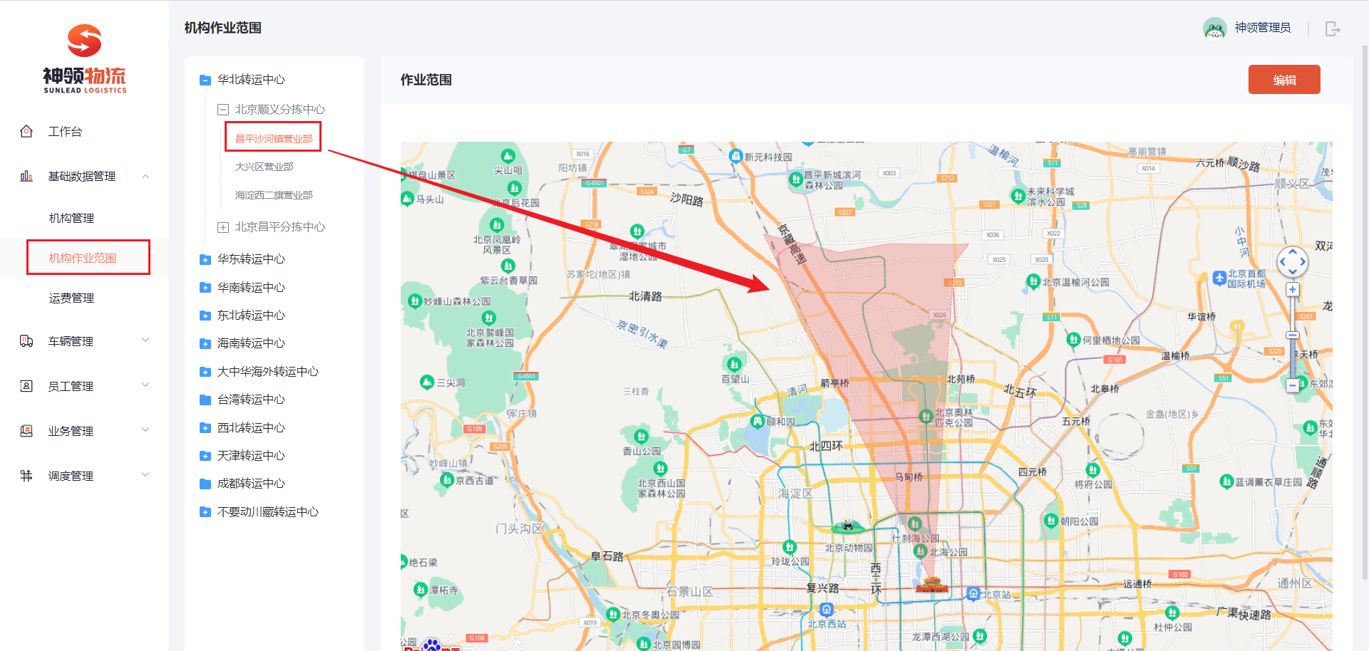
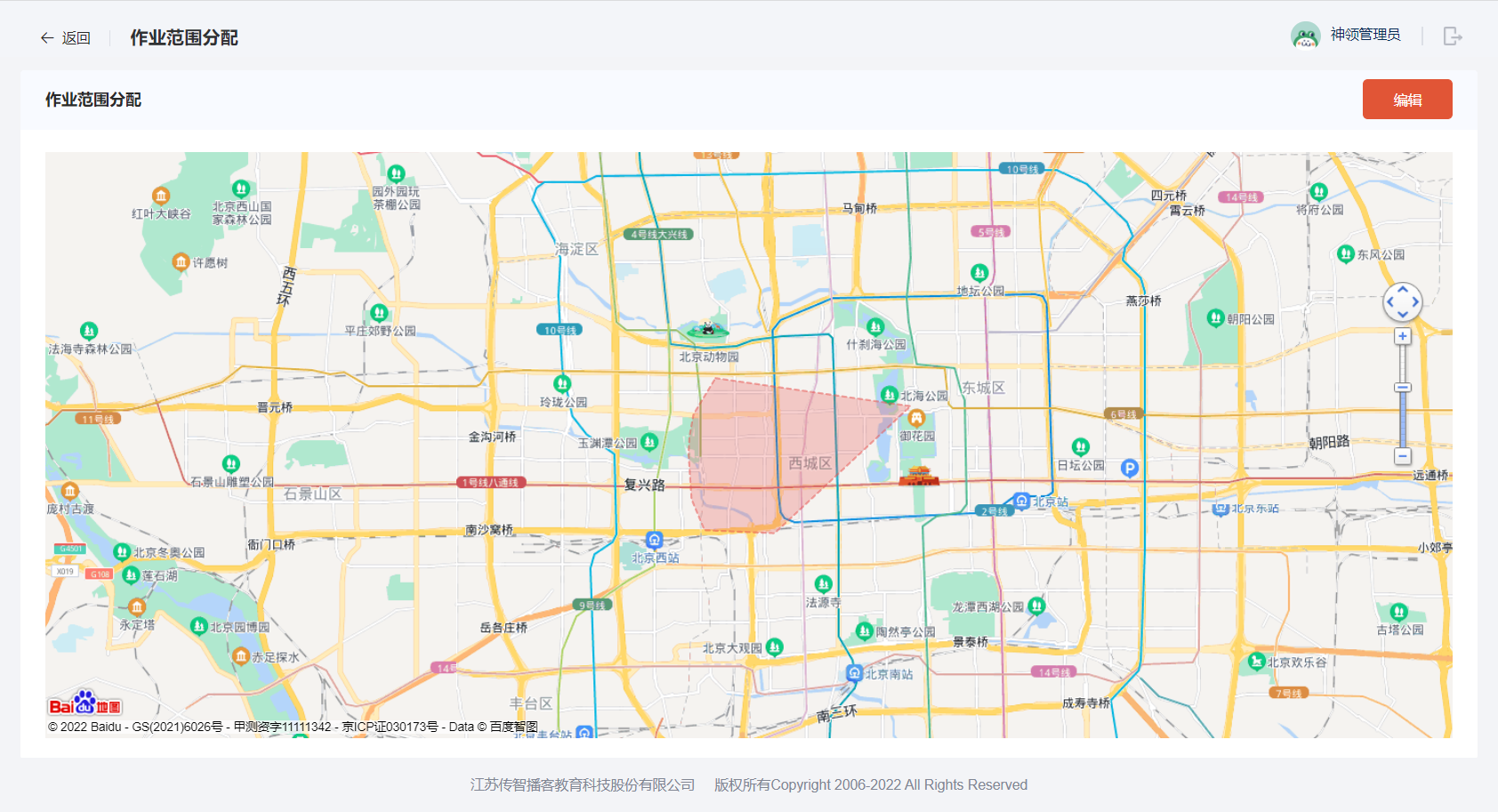
在项目中,会有两个作业范围,分别是机构作业范围和快递员作业范围,这两个作业范围的逻辑是一致的,就是在地图中进行画出范围,就是其作业范围。
实现分析
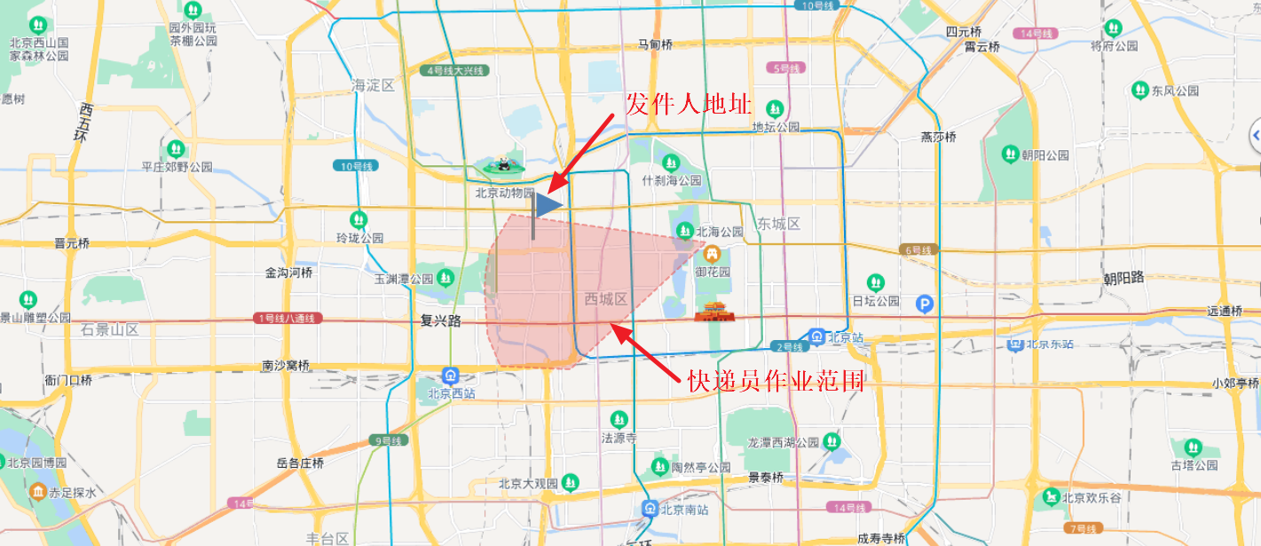
对于作业范围是一个由多个坐标点组成的多边形,并且必须是闭合的多边形,这个就比较适合用MongoDB来存储。 现在想一个实际需求,用户小王下了订单,如何找到属于该服务范围内的快递员呢?这个就需要使用MongoDB的$geoIntersects查询操作,其原理就是查找小王的位置坐标点与哪个多边形有交叉,这个就是为其服务的快递员。
在配置中引入了MongoDB和EagleMap的共享配置。
server:
  port: 18089
  tomcat:
    uri-encoding: UTF-8
    threads:
      max: 1000
      min-spare: 30
spring:
  cloud:
    nacos:
      username: nacos
      password: nacos
      server-addr: 192.168.150.101:8848
      discovery:
        namespace: ecae68ba-7b43-4473-a980-4ddeb6157bdc
      config:
        namespace: ecae68ba-7b43-4473-a980-4ddeb6157bdc
        shared-configs: #共享配置
          - data-id: shared-spring-mongodb.yml
            group: SHARED_GROUP
            refresh: false
          - data-id: shared-spring-eaglemap.yml
            group: SHARED_GROUP
            refresh: false
ServiceScopeEntity
机构和快递员的逻辑是一样的,所以可以共存一张表中,通过type进行区分,1-机构,2-快递员。
/**
 * 服务范围实体
 */
@Data
@Document("sl_service_scope")
public class ServiceScopeEntity {

    @Id
    @JsonIgnore
    private ObjectId id;

    /**
     * 业务id,可以是机构或快递员
     */
    @Indexed
    private Long bid;

    /**
     * 类型 {@link com.sl.ms.scope.enums.ServiceTypeEnum}
     */
    @Indexed
    private Integer type;

    /**
     * 多边形范围,是闭合的范围,开始经纬度与结束经纬度必须一样
     * x: 经度,y:纬度
     */
    @GeoSpatialIndexed(type = GeoSpatialIndexType.GEO_2DSPHERE)
    private GeoJsonPolygon polygon;

    private Long created; //创建时间
    private Long updated; //更新时间
}
服务类型枚举:
/**
 * 服务类型枚举
 */
public enum ServiceTypeEnum {

    ORGAN(1, "机构"),
    COURIER(2, "快递员");

    /**
     * 类型编码
     */
    private final Integer code;

    /**
     * 类型值
     */
    private final String value;


    ServiceTypeEnum(Integer code, String value) {
        this.code = code;
        this.value = value;
    }

    public Integer getCode() {
        return code;
    }

    public String getValue() {
        return value;
    }

    public static ServiceTypeEnum codeOf(Integer code) {
        return EnumUtil.getBy(ServiceTypeEnum::getCode, code);
    }
}
ScopeService 在ScopeService中主要定义了如下方法:
● 新增或更新服务范围
● 根据主键id删除数据
● 根据业务id和类型删除数据
● 根据主键查询数据
● 根据业务id和类型查询数据
● 根据坐标点查询所属的服务对象
● 根据详细地址查询所属的服务对象
/**
 * 服务范围Service
 */
public interface ScopeService {

    /**
     * 新增或更新服务范围
     *
     * @param bid     业务id
     * @param type    类型
     * @param polygon 多边形坐标点
     * @return 是否成功
     */
    Boolean saveOrUpdate(Long bid, ServiceTypeEnum type, GeoJsonPolygon polygon);

    /**
     * 根据主键id删除数据
     *
     * @param id 主键
     * @return 是否成功
     */
    Boolean delete(String id);

    /**
     * 根据业务id和类型删除数据
     *
     * @param bid  业务id
     * @param type 类型
     * @return 是否成功
     */
    Boolean delete(Long bid, ServiceTypeEnum type);

    /**
     * 根据主键查询数据
     *
     * @param id 主键
     * @return 服务范围数据
     */
    ServiceScopeEntity queryById(String id);

    /**
     * 根据业务id和类型查询数据
     *
     * @param bid  业务id
     * @param type 类型
     * @return 服务范围数据
     */
    ServiceScopeEntity queryByBidAndType(Long bid, ServiceTypeEnum type);

    /**
     * 根据坐标点查询所属的服务对象
     *
     * @param type  类型
     * @param point 坐标点
     * @return 服务范围数据
     */
    List<ServiceScopeEntity> queryListByPoint(ServiceTypeEnum type, GeoJsonPoint point);

    /**
     * 根据详细地址查询所属的服务对象
     *
     * @param type    类型
     * @param address 详细地址,如:北京市昌平区金燕龙办公楼传智教育总部
     * @return 服务范围数据
     */
    List<ServiceScopeEntity> queryListByPoint(ServiceTypeEnum type, String address);
}
实现接口
package com.sl.ms.scope.service.impl;

import cn.hutool.core.util.ObjectUtil;
import com.itheima.em.sdk.EagleMapTemplate;
import com.itheima.em.sdk.enums.ProviderEnum;
import com.itheima.em.sdk.vo.Coordinate;
import com.itheima.em.sdk.vo.GeoResult;
import com.sl.ms.scope.entity.ServiceScopeEntity;
import com.sl.ms.scope.enums.ServiceTypeEnum;
import com.sl.ms.scope.service.ScopeService;
import lombok.extern.slf4j.Slf4j;
import org.bson.types.ObjectId;
import org.springframework.data.geo.Point;
import org.springframework.data.mongodb.core.MongoTemplate;
import org.springframework.data.mongodb.core.geo.GeoJsonPoint;
import org.springframework.data.mongodb.core.geo.GeoJsonPolygon;
import org.springframework.data.mongodb.core.query.Criteria;
import org.springframework.data.mongodb.core.query.Query;
import org.springframework.stereotype.Service;

import javax.annotation.Resource;
import java.util.List;

@Slf4j
@Service
public class ScopeServiceImpl implements ScopeService {

    @Resource
    private MongoTemplate mongoTemplate;
    @Resource
    private EagleMapTemplate eagleMapTemplate;

    @Override
    public Boolean saveOrUpdate(Long bid, ServiceTypeEnum type, GeoJsonPolygon polygon) {
        Query query = Query.query(Criteria.where("bid").is(bid).and("type").is(type.getCode())); //构造查询条件
        ServiceScopeEntity serviceScopeEntity = this.mongoTemplate.findOne(query, ServiceScopeEntity.class);
        if (ObjectUtil.isEmpty(serviceScopeEntity)) {
            //新增
            serviceScopeEntity = new ServiceScopeEntity();
            serviceScopeEntity.setBid(bid);
            serviceScopeEntity.setType(type.getCode());
            serviceScopeEntity.setPolygon(polygon);
            serviceScopeEntity.setCreated(System.currentTimeMillis());
            serviceScopeEntity.setUpdated(serviceScopeEntity.getCreated());
        } else {
            //更新
            serviceScopeEntity.setPolygon(polygon);
            serviceScopeEntity.setUpdated(System.currentTimeMillis());
        }

        try {
            this.mongoTemplate.save(serviceScopeEntity);
            return true;
        } catch (Exception e) {
            log.error("新增/更新服务范围数据失败! bid = {}, type = {}, points = {}", bid, type, polygon.getPoints(), e);
        }
        return false;
    }

    @Override
    public Boolean delete(String id) {
        Query query = Query.query(Criteria.where("id").is(new ObjectId(id))); //构造查询条件
        return this.mongoTemplate.remove(query, ServiceScopeEntity.class).getDeletedCount() > 0;
    }

    @Override
    public Boolean delete(Long bid, ServiceTypeEnum type) {
        Query query = Query.query(Criteria.where("bid").is(bid).and("type").is(type.getCode())); //构造查询条件
        return this.mongoTemplate.remove(query, ServiceScopeEntity.class).getDeletedCount() > 0;
    }

    @Override
    public ServiceScopeEntity queryById(String id) {
        return this.mongoTemplate.findById(new ObjectId(id), ServiceScopeEntity.class);
    }

    @Override
    public ServiceScopeEntity queryByBidAndType(Long bid, ServiceTypeEnum type) {
        Query query = Query.query(Criteria.where("bid").is(bid).and("type").is(type.getCode())); //构造查询条件
        return this.mongoTemplate.findOne(query, ServiceScopeEntity.class);
    }

    @Override
    public List<ServiceScopeEntity> queryListByPoint(ServiceTypeEnum type, GeoJsonPoint point) {
        Query query = Query.query(Criteria.where("polygon").intersects(point)
                .and("type").is(type.getCode()));
        return this.mongoTemplate.find(query, ServiceScopeEntity.class);
    }

    @Override
    public List<ServiceScopeEntity> queryListByPoint(ServiceTypeEnum type, String address) {
        //根据详细地址查询坐标
        GeoResult geoResult = this.eagleMapTemplate.opsForBase().geoCode(ProviderEnum.AMAP, address, null);
        Coordinate coordinate = geoResult.getLocation();
        return this.queryListByPoint(type, new GeoJsonPoint(coordinate.getLongitude(), coordinate.getLatitude()));
    }
}
测试
@SpringBootTest
public class ScopeServiceTest {
@Resource
private ScopeService scopeService;
@Test
void saveOrUpdate() {
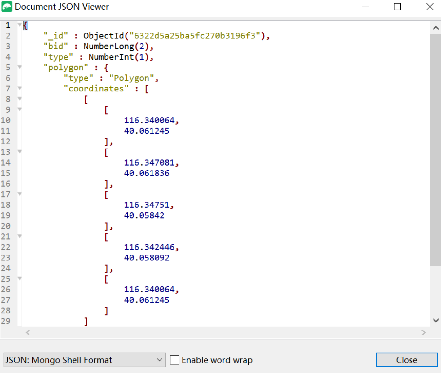
List<Point> pointList = Arrays.asList(new Point(116.340064,40.061245),
new Point(116.347081,40.061836),
new Point(116.34751,40.05842),
new Point(116.342446,40.058092),
new Point(116.340064,40.061245));
Boolean result = this.scopeService.saveOrUpdate(2L, ServiceTypeEnum.ORGAN, new GeoJsonPolygon(pointList));
System.out.println(result);
}
@Test
void testQueryListByPoint() {
GeoJsonPoint point = new GeoJsonPoint(116.344828,40.05911);
List<ServiceScopeEntity> serviceScopeEntities = this.scopeService.queryListByPoint(ServiceTypeEnum.ORGAN, point);
serviceScopeEntities.forEach(serviceScopeEntity -> System.out.println(serviceScopeEntity));
}
@Test
void testQueryListByPoint2() {
String address = "北京市昌平区金燕龙办公楼";
List<ServiceScopeEntity> serviceScopeEntities = this.scopeService.queryListByPoint(ServiceTypeEnum.ORGAN, address);
serviceScopeEntities.forEach(serviceScopeEntity -> System.out.println(serviceScopeEntity));
}
}
练习:实现附近的人搜索
    /**
     * 查询附近的人的所有用户id
     *
     * @param userId 用户id,中心点用户
     * @param metre  距离,单位:米
     * @return 附近的人
     */
    @Override
    public List<Long> queryNearUser(Long userId, Double metre) {
        //1、根据用户id,查询用户的位置信息
        Query query = Query.query(Criteria.where("userId").is(userId));
        UserLocation location = mongoTemplate.findOne(query, UserLocation.class);
        if (location == null) {
            return null;
        }
        //2、以当前用户位置绘制原点
        GeoJsonPoint point = location.getLocation();
        //3、绘制半径
        Distance distance = new Distance(metre / 1000, Metrics.KILOMETERS);
        //5、构建查询对象
        NearQuery nearQuery = NearQuery.near(point).maxDistance(distance);
        //6、执行查询,由近到远排序
        GeoResults<UserLocation> geoResults = mongoTemplate.geoNear(nearQuery, UserLocation.class);

        //7、获取结果对象,其中userLocationGeoResult.getDistance()可以获取目标点与中心点的位置
        return geoResults.getContent().stream()
                .map(userLocationGeoResult -> userLocationGeoResult.getContent().getUserId())
                .collect(Collectors.toList());
    }
模拟面试
- ● MongoDB存储的数据结构与MySQL存储的数据结构有什么区别?
- ● 为什么会使用到MongoDB?MongoDB中如何存储坐标位置数据?如何实现附近的人查询?
- ● 用户下单后如何确定为其服务的快递员?如何确定起点、终点的机构?
- ● 作业范围如果不使用MongoDB,还可以使用其他技术实现吗?


评论( 0 )